NEWS 2007
TEXAS GLOBE PROGRAM
El Paso GLOBE off to Spain!
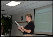
The GLOBE Program Coordinator, Robin Hoffer, PhD, from EL Paso Partnership and Albert Ortiz with Joel Gilbert will be presenting a poster/paper at the International Geoscience and Remote Sensing Symposium in Barcelona, Spain during July, 2007.
 The focus of the presentation will be about
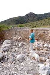
the El Paso flood that was reported on August 1, 2006. El Paso
experienced 7 1/2 inches (~ 185 mm) in 3 hours. This was especially
damaging since most of it occurred on the Franklin Mountain
which bisects the city of El Paso and towers over 3000 ft. above it.
The focus of the presentation will be about
the El Paso flood that was reported on August 1, 2006. El Paso
experienced 7 1/2 inches (~ 185 mm) in 3 hours. This was especially
damaging since most of it occurred on the Franklin Mountain
which bisects the city of El Paso and towers over 3000 ft. above it.
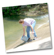
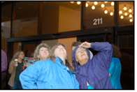
In the photo to the left you can see Dr. Hoffer walking where once there were torrents of water eroding the mountainside and transporting large boulders.
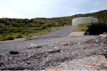 The rain was so forceful that it even washed
away part of the road and walkway in the Franklin Mountains.
The rain was so forceful that it even washed
away part of the road and walkway in the Franklin Mountains.
GLOBE graphs of the rainfall during the rains of July, Aug. and Sept. 2006 will be prominent on their poster. For more information please read the following abstract.
GLOBE Students in Sunland Park, New Mexico Study Satellite Images to Decipher August 2006 Flood Damage.
Dr. Robin L. Hoffer, Albert Ortiz and
Joel Gilbert
University of Texas at El Paso
Department of Geological Sciences
500 W University St.
El Paso, Texas 79968
[email protected]
Abstract
Students at Desert View Elementary
School in Sunland Park, New Mexico have been involved in the GLOBE
(Global Learning and Observations to Benefit the Environment) Program
for several years. As part of their GLOBE instruction teacher Albert
Ortiz introduced his students to the basic concepts of satellite imagery
and remote sensing. The students were first shown how the images are
composed of tiny dots called “pixels”, and that a pixel represents the
instantaneous field of view of the ground surface imaged. Students were
also taught that the ground surface area represented by one pixel in a
satellite image is called “ground resolution” and that the greater the
number of pixels per inch, the greater the resolution. The students
also learned that satellites transmit these pixel images to ground
stations as digital signals, which represent the ground surface being
imaged. It is through these lessons, ground surface reflectivity and
light’s behavior as it is sent back to a satellite’s sensors, that Ortiz
is able to demonstrate to these elementary school students how these
images are made. In these lessons, a grayscale image, which may vary
in tone, is presented to the class. Then false color is added to
emphasize a particular feature, such as vegetation. The class is then
introduced to the electromagnetic spectrum and is shown how different
wavelengths of light produce the false color images that appear in
satellite imagery. They are taught that satellite sensors operate by
picking up the way light is reflected from various surfaces. The
students are using this knowledge to study changes in their watershed
caused by the August 2006 monsoons. The Sunland Park, New Mexico,
Juarez, Mexico and El Paso, Texas region experienced severe flooding as a
result of torrential rains that hit the area in August 2006. Ortiz
requested and received a set of aerial photographs of damage in Juarez
from the Mexican Government and LandSat images of El Paso, Texas from
GLOBE headquarters taken before and after the flooding. Using these
copies, he instructed the students to study the changes that had taken
place in the watersheds of the Juarez and Franklin Mountains over that 3
month period. He had the students tape transparent sheets over the
images and label major streets and sites e.g. their school. They were
then asked to study the images to see what effect land development,
particularly in areas where major arroyos drain the mountain slopes,
added to the flooding and damage at the base of the mountains. Through
studying and comparing the aerial photographs and NASA images the
students were able to see how much change had taken place in the arroyo
drainage both from natural causes and by residential development on the
mountain slopes. They also learned what valuable tools satellite images
have become.
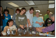
Informal Educators Meet GLOBE
 January 11-12, 2007
On January 11-12, 2007, The Texas Environmental Education Advisory Committee (TEEAC) hosted its annual meeting to over 70 informal environmental educators. TEEAC coordinates with other state agencies and is charged with the development of environmental education materials. It cooperates with a network of 120 providers of environmental education professional development, including universities, industry, museums, and nature centers. This network of TEEAC Sites and Programs helps assure that teacher professional development offered by formal and non-formal providers is educationally sound and consistent with the Texas Essential Knowledge and Skills (TEKS).
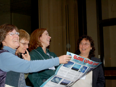
 The GLOBE Program was featured at this meeting. Jennifer Jordan, GLOBE
Trainer and science specialist at the Education Service Center, Region
13 in Austin, Texas led the presentation and provided hands-on
activities. The participants were introduced to three of the
domains-atmosphere, soils and hydrology. They participated in
activities from each domain.
The GLOBE Program was featured at this meeting. Jennifer Jordan, GLOBE
Trainer and science specialist at the Education Service Center, Region
13 in Austin, Texas led the presentation and provided hands-on
activities. The participants were introduced to three of the
domains-atmosphere, soils and hydrology. They participated in
activities from each domain.
 Jennifer began by introducing the atmospheric domain. The participants
took part in a cloud cover exercise in the classroom and then went out
doors to observe the sky and use their new skills. It was an
enlightening, albeit wet, exercise due to the rain.
Jennifer began by introducing the atmospheric domain. The participants
took part in a cloud cover exercise in the classroom and then went out
doors to observe the sky and use their new skills. It was an
enlightening, albeit wet, exercise due to the rain.
 The second domain focused on hydrology. Each group of participants
focused on an activity called Water Detectives. It is a wonderful
activity where they participants had to use their senses to determine
what each clear liquid was.
The second domain focused on hydrology. Each group of participants
focused on an activity called Water Detectives. It is a wonderful
activity where they participants had to use their senses to determine
what each clear liquid was.
In the last domain, soils, Jennifer had the participants look at different types of soil. They conducted an activity called Just Passing Through. Participants made predictions about which soil would have the water pass through the fastest and which would retain the most water. Many were surprised with the results.
Jennifer did such a fantastic job with her presentation that many of the informal educators requested a Trainer of Trainer workshop this summer. As soon as dates are determined, the Texas Regional Collaboratives GLOBE Partnership will provide the training.
You are invited to view all the images of this event in the album, TEEAC GLOBE 01/07, located within the Texas GLOBE gallery.
TEEAC is sponsored by The Texas Education Agency. If you would like more information please contact:
Irene Pickhardt; Texas Education Agency; 1701 N. Congress; Austin, TX 78701; 512463-9566; [email protected] Irene Pickhardt
Texas GLOBE Site hosted by
The Texas Regional Collaboratives for Excellence in Science
and Mathematics Teaching
For questions, contact: Marsha Willis